

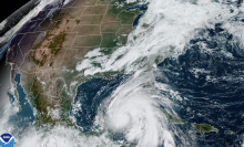
Another storm has rapidly intensified. This time, it’s Hurricane Milton.
The hurricane is projected to make landfall on the west coast of the Florida peninsula on Wednesday night or early Thursday, and is tracking towards the well-populated Tampa Bay region, or areas just south. The hurricane jumped from a Category 1 to 5 in under a day.
For those in the Tampa area or interested in the storm’s impacts there, you can watch on the webcams below.
This hurricane will undoubtedly be life-threatening. “Prepare for MAJOR impacts from storm surge, hurricane winds, & flooding rainfall far from the center,” the National Weather Service’s Tampa Bay office posted online. Watch for guidance from local National Weather Service offices and other relevant agencies for updates and evacuation information.
Though a number of factors influence the formation of strong hurricanes (opposing winds that can break apart storms, moist or dry air, etc.), a vital influence is warm sea surface temperatures of over 80 degrees Fahrenheit (27 degrees Celsius). Warm oceans act as jet fuel for hurricanes, storm scientists explain. That’s because warmer oceans fuel tropical storms as more water naturally evaporates into the air, giving storms energy and moisture to intensify. Crucially, the oceans, which absorb most of the heat created by burning fossil fuels, are relentlessly warming.
Today, Atlantic hurricanes are already twice as likely to develop from a milder storm into a major hurricane.
Tampa Bay Riverfront webcam
Siesta Key Beach (off the coast of Sarasota)
(You may need to click the video to watch it on YouTube.)
Clearwater Beach Hilton
Clearwater Pier Cam
And remember, as you’re watching the slightly shifting track updates of Hurricane Milton, the track forecast cone is not an impacts cone. Other regions will see extreme deluges of rain, surge, and flooding.
https://mashable.com/article/hurricane-milton-tampa-bay-webcams-livestreams